Wednesday 21 March 2012

Bear Street, Bear Gate & Bear Tower

Today Bear Street hardly exists. The north side is nothing but a car park hidden behind a modern wall and the south side is completely dominated by the side wall of a late 19th century church left. But the area is thick with history and Bear Street, just 180ft (56m) long, was the site of several structures of significant historical interest. Traces of its medieval past remained until 1966 and yet none of it now survives. So what went wrong?

The site of Bear Street is ancient, lying within the boundaries of the mid-1st century Roman fortress. In 1953 part of a Roman drain or conduit was found in Bear Street. The drain carried waste water away from the public baths which stood near the Deanery's garden c180 AD. There is some archaeological evidence that Bear Street was first laid out on its current alignment as early as the 9th century. It might've once connected South Street with the Anglo-Saxon minster which stood just west of the present Gothic cathedral. According to this theory, Saxon Bear Street would've been much longer than it is today, extending across the city as far as what is now Princesshay. The street was considerably shortened in length when the boundaries of the cathedral precinct were established and by the end of the 13th century it only led to Deanery Place and Palace Gate, as it still does today. In 1286, following the murder of the precentor Walter Lechlade, the Dean and Chapter received a royal licence from Edward I to encircle the cathedral precinct with a wall and gatehouses, and one of these gatehouses was situated in Bear Street.

The Bear Gate

A document relating to the circumvallation gives quite precise details about the location of the gate, later known as Bear Gate. It was located at the top of Bear Street and consisted of one gate 8ft wide for pack-horses leading into "the lane between the house of the Dean of Exeter and the house now of Roger de Derteford". The gate had wooden doors that were locked every evening at the curfew. It must've been a relatively simple structure, especially in comparison with the great Broad Gate on the High Street. Hooker's 16th century plan of South Street shows Bear Gate with a simple pitched roof. On the Braun and Hogenburg map of 1587 the gate consists of just a stone archway right. The range of buildings on the right side of the street formed the north wall of the Bear Inn, the former townhouse of the Abbots of Tavistock Abbey.

There's some evidence that by 1584 the gate had a chamber above it as a Mr Barcombe was required to pay two pence every year in consideration of "his new building over the gate going into the churchyard by the said Bear Gate". The Bear Gate was demolished in the Spring of 1813. According to Michael Fodor in his booklet 'Gates of the Close', the materials were salvaged by Thomas Matthews for £10.

The Bear Tower

Of almost equal interest was the Bear Tower. It was embedded within a later property, close to the junction with South Street and opposite the side wall of the Bear Inn. It dated at least to the 14th century and was built from blocks of purple volcanic trap. A blocked Gothic doorway in the south wall of the tower once gave access directly onto Bear Street. There was also a very large blocked archway in the east wall, almost like the chancel arch of a church. The tower was perhaps 20ft high and approximately 15ft square at the base. Jenkins saw it in 1806: "The opposite corner of Bear Lane bears evident marks of antiquity. According to tradition it was a Nunnery". Lega-Weekes also recalled seeing the property in 1915: "The ancient side wall of the house at one corner of Bear Lane shews traces in its masonry of a large arched window or doorway at first floor level, and a smaller stopped window above that; and this, like other old masonry in the house is about three feet thick".

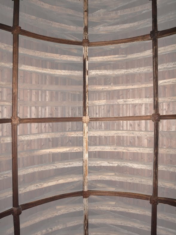
The drawing above left © Devon County Council is by local artist John Gendall and dates to c1840. It shows the interior of the Bear Tower. The partially open door which once exited onto Bear Street is visible in the centre. A stone spiral staircase can be seen rising through the centre of the tower. (The staircase was removed c1860.) No-one knows the function of the Bear Tower. Jenkins believed it was related to an Augustinian nunnery which was possibly on this site. It's also possible that it was connected to an earlier phase of the townhouse of the Abbots of Tavistock, on the other side of the street. The townhouse was reputedly rebuilt in 1481 and perhaps the Bear Tower was part of the earlier townhouse. The Bear Gate always seems to have been located at the other end of Bear Street so it's unlikely that the Bear Tower was related to that. The purpose of the tower remains a mystery. The image below right shows Bear Street as it appears on Hedgeland's early 19th century model of Exeter.

During the Exeter Blitz of 1942 the early 19th century house which had been built around the Bear Tower was destroyed by fire. But the fire was no match for the tower's thick masonry and a significant amount of the 14th century structure remained standing (much like the Gothic windows and medieval walls at the Black Lions Inn on the other side of South Street). The Bear Tower stood on the corner of Bear Street and South Street for a further 24 years.

Despite being listed as one of Exeter's ancient monuments in the 1950s, in December 1965 the city council obtained permission from the Minister of Public Works to demolish the tower completely. In an act of either gross stupidity or pig ignorance, the remains of the 14th century building were destroyed in January 1966. It's not surprising that some people believe the philistine post-war city council merely finished what the Germans had already started in 1942. The government had stipulated that the foundations be left preserved and exposed. Naturally, this didn't happen and today the site of the Bear Tower is a flower bed.

Nos. 2 to 8, Bear Street

The image left shows a detail from the 1905 OS map of Exeter overlaid onto an aerial view of the same area. Properties demolished since 1905 are highlighted in red.

The Bear Tower wasn't the only historical structure on Bear Street which managed to stagger into the 20th century. Nos. 2 to 8 Bear Street occupied almost the entire north side of the street, facing out onto the side wall of the Bear Inn (and later the Roman Catholic Church of the Sacred Heart). An auction annoucement in 1809 stated that several of these houses, "situate adjoining Bear Gate, and fronting Bear Lane" were held "by lease under the Dean of Exeter". In fact all of these properties on the north side of the street were owned by the Dean and Chapter and were part of the boundary between the city and the cathedral precinct.

In the summer of 1871 the 'Exeter Flying Post' carried a report that the Dean, in conjunction with the city council, had decided to authorise the widening of Bear Street "on the north side by fifteen feet throughout, from the junction with Palace Street to the last house fronting South Street". The fronts of the houses on the north side of Bear Street were all apparently set back to allow the road to be widened. I'm not convinced that this actually happened to the extent suggested in the newspaper report. Either way, the rears of Nos. 2 to 8 Bear Street were much older than the street facades. Arthur Everett examined the row of properties in the 1930s and discovered that the back walls and roofs dated to c1500. The great age of the buildings was of little consequence as the entire lot was demolished in 1938. It never seems to have occurred to the local authority that Exeter's stock of medieval housing was a finite resource. It's a sobering thought that more medieval and early post-medieval buildings were probably demolished in Exeter between 1900 and 1939 than were ever destroyed during World War Two.

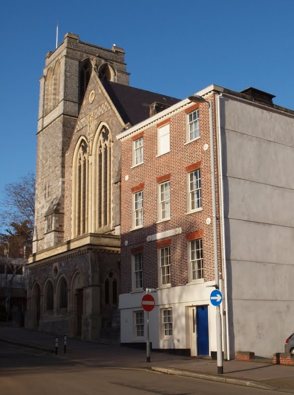
The location of the ancient houses today is a car park partially hidden behind a shabby wall. There's now no sign above ground of the Bear Gate or the Bear Tower, the ancient houses or the old Bear Inn. The photograph below shows the site of the Bear Tower, the foundations lying somewhere beneath the flowerbed to the right of the remarkably poor flat-roofed post-war shack on South Street. The entrance into Bear Street is visible to the far right.

Sources

Sunday 18 March 2012

The Bear Inn on South Street & the Abbots of Tavistock

Tavistock lies about 30 miles west of Exeter, town and city separated by the wild granite upland of the Dartmoor National Park. The abbey at Tavistock was founded in 974 by Ordulf, an Anglo-Saxon Ealdorman of Devon, and received its Royal Charter from King Ethelred II in 981.

Ordulf, reputedly a giant of enormous stature, has some connection with Exeter. A story recounted by William of Malmesbury in the 12th century states how Ordulf broke open the doors of the city's East Gate using just his foot.

Swelled by endowments of land and property across Devon and Cornwall, the abbey grew throughout the Middle Ages to become the wealthiest monastic foundation in the south-west of England. Medieval Exeter was the pre-eminent religious, cultural and economic centre of Devon and Cornwall. Priors and abbots from across the region had residences within the city for their own private use. These included the Abbots of Torre, Hartland, Dunkeswell, Buckfast and Newenham. The Abbots of Tavistock Abbey had property in the city at a very early date. The Domesday Book of 1086 records that the abbey possessed a house in Exeter obtained from lending money to a burgess, one of Exeter's citizens, and receiving the house as a sort of bond or pledge in return.

The image above shows the original entries from the Domesday Book relating to the monastery's Exeter property. "Terra Eccle de Tavestock" refers to the ecclesiastical lands owned by the abbey. Included in the list of lands owned by the abbey is the lower extract. It refers directly to Exeter ("In civitate Exonia") and the house ("una domu") of a burgess. The property generated 8d in customs to the king. Was this Saxo-Norman property the seed from which the opulent townhouse on South Street later flowered? It is impossible to say as its location is unknown but it remains an exciting possibility.

It is certain though that the Abbots of Tavistock did have a townhouse in Exeter and it was located on the corner of Bear Street and South Street. It formed part of a remarkable collection of properties from the Late Middle Ages which clustered around the south side of Exeter Cathedral left

These included the Deanery, the Bishop's Palace, the Chantry and the Archdeacon of Exeter's House. On the other side of South Street, almost opposite the Abbot of Tavistock's residence, was the townhouse of the Prior of Plympton Priory, later the Black Lions Inn. It's worth remembering that, along with the cathedral itself, there were also over thirty chapels and churches, a Benedictine priory, a Dominican friary and numerous canons' houses, all contained within the 93 acres of the medieval walled city.

It's not known how frequently the abbots stayed at their Exeter townhouse or when it was first used as an inn. By the 16th century at least it was being rented out to citizens of the city.
In 1535 "Le Bere Inn alias Bere" situated in "vico Australi" i.e. South Street, was leased by the last abbot, John Peryn, to Edward Bridgeman and his wife, Jane. This Edward Bridgeman was probably the Warden of Exebridge. Only a citizen of significant wealth could've afforded to take on the tenancy of the abbots' residence. Tavistock Abbey was engulfed by the Dissolution of the Monasteries and in 1539 the abbey was surrendered to the king.

The abbey buildings were demolished and its lands scattered, many of them falling into the hands of John Russell, the 1st Earl of Bedford and owner of Bedford House in Exeter. (The eldest son of the Duke of Bedford still holds the title of Marquess of Tavistock.) In 1546 William Abbot was sold the lease of "the Beare Inn at Exeter, late of the monastery of Tavestock" by Henry VIII for £20. (This was presumably the same William Abbot, Sergeant of the Wine Cellar at Hampton Court, who also received the buildings at Hartland Abbey in North Devon.) Abbot sold the premises just two years later to Griffin Ameridith and John Fortescue. In 1566 the city's former mayor, William Bucknam, endowed Grendon's Almshouses in Preston Street with the Bear Inn, and the site remained in the possession of the trustees of the Grendon charity until the 1880s.

Precise details of the abbots' townhouse remain elusive. The most intriguing source for the property's medieval appearance is Alexander Jenkins' description of 1806: "Great part of the old buildings, particularly the Chapel, was standing a few years since; they were built from freestone, of excellent Gothic workmanship, decorated with fretwork panels, mutilated inscriptions, and different sculptures were seen, and over the cornice even with the battlements was a cabossed statue of a Bear, holding a ragged staff between its paws". Another brief description from 1701 mentions that the coat of arms of Tavistock Abbey and its founder were to be seen in painted glass in the great window of the dining room along with the figure of a man standing on a bridge (a reference to the above-mentioned Edward Bridgeman who must've had that particular detail installed in the 1530s).

The crenellated building mentioned by Jenkins probably functioned as a gatehouse with a central passageway leading from South Street into an inner courtyard, around which might've been grouped the dining hall, chapel, private chambers and service rooms. The exact layout is unknown and it's impossible to say what alterations were made to the property once it entered lay ownership in the 16th century. It must've all been built on a lavish scale commensurate with the wealth of the abbey itself and should perhaps be regarded as one of Exeter's most significant medieval houses. The embattled front of the Bear Inn, undoubtedly an impressive sight in its own right, seems to feature on both the 1587 Braun and Hogenberg map of Exeter (based on a plan by John Hooker) and also on Hooker's own 16th century plan of South Street, both left.

Throughout the 17th and 18th centuries the Bear Inn was a focus for Exeter's lucrative woollen cloth trade. The inn's close proximity to the Serge Market on South Street resulted in it becoming a centre of commerce in its own right. According to Hoskins, "thousands of pounds changed hands" at the inn on market days as dealers met within the extensive premises to trade with each other. The Serge Market had been moved to South Street by the late 1600s. When Daniel Defoe visited Exeter in 1727 he described the market as "well worth a Stranger's seeing" and believed it to be the "greatest in England" after the market in Leeds. He was also told that the market could generate up to £100,000 in transactions every week. The Bear Inn was also one of the places in the city where Charles II was proclaimed as King of England following the Restoration in 1660.

Throughout the 1600s and 1700s, the Bear Inn was an important centre for carrier services (the equivalent today would be something like the Royal Mail's Parcelforce, TNT or Fedex). The carrier service involved the transportation of goods rather than people and used enormous 'flying wagons' stacked high with various merchandise. By c1798, one of these carrier companies, headed by Robert Russell, was operating from the Bear Inn. In 1800, having taken out a lease on the premises, he set about rebuilding it. Jenkins reported in 1806 that "This venerable pile of buildings being in a ruinous state, was pulled down, and a dwelling house, offices, etc. erected on the site, by Mr. Robert Russell".

It's difficult to know the exact nature of Russell's alterations but it's clear that significant portions of the old Bear Inn survived the remodelling.

The image right shows the extent of Russell's premises as they appear on the 1876 Ordnance Survey map overlaid onto a modern aerial view of the same area. The premises have been highlighted to show three quite distinct elements. The building highlighted in purple still survives as No. 25 South Street. This was probably the newly-constructed "dwelling house" mentioned by Jenkins and was a product of the c1800 rebuilding. The house was used by Russell as his own private residence. The property is now known as The Presbytery and is associated with the Church of the Sacred Heart. The large area highlighted in red was also part of the early 19th century alterations, although it's possible that bits of the Bear Inn remained embedded within the later construction. These were the business's offices and warehouses. The entrance from South Street was through large arched openings leading into a spacious courtyard around which were grouped warehouses, a granary, stables, blacksmiths' and wheelers' workshops and a counting house. The openings in the front of the building allowed the wagons to enter the premises directly from the street.

The most interesting part of the premises is highlighted in yellow. According to the 1876 map, this long, narrow plot was the 'Abbot's Town House (Tavistock)'. It was certainly a large fragment of it, probably the north range which extended from South Street all the way along the south side of Bear Street as far as the boundary wall of the Chantry in Deanery Place. This was to become the house and/or offices of Russell's Exeter manager and business partner, Robert Thomas. I believe that the entirety of Russell's premises shown on the 1876 OS map retained at least the approximate footprint of the abbot's 15th century townhouse, possibly including the central courtyard. Comparison with cars and vans shown in the aerial photograph gives some indication of its enormous size.

The sketch of 1881 left, which I've crudely coloured, depicts the South Street facades which made up Russell's wagon offices and warehouse. It is the only known image of these structures in existence. The brick building to the far right, Russell's own house, is the still-surviving No. 25 South Street. Next to it are the four arched openings which led into the courtyard behind. This central part probably replaced the embattled gatehouse structure mentioned by Jenkins and depicted in the 16th century by Hooker and Hogenberg.

To the left, coloured yellow and standing on the corner of South Street and Bear Street, is the property labelled as the 'Abbot's Town House' on the 1876 map. It is quite clearly of an earlier date compared with the other buildings. It's difficult to be sure but the side wall at least, disappearing down Bear Street, was almost certainly made of thick stone walling. The single bay, three-storey facade under a hipped roof was probably timber-framed and post-dated the Reformation. According to Lega-Weekes, a forge stood further up Bear Lane at the rear of the Bear Inn where the horses that pulled Russell's wagons were shod. The photograph below right shows the site of the Abbot of Tavistock's townhouse today. Russell's residence at No. 25 South Street is to the right. The rest of the buildings shown in the 1881 sketch are on the site of the Catholic Church of the Sacred Heart.

The Bear Inn continued in operation in some form as an inn even after Russell's alterations of c1800 which, according to Jenkins, saw the "venerable pile" demolished (although something of it clearly survived).

An announcement in the 'Exeter Flying Post' dated 03 December 1801 stated that John Holman had taken on the Bear Inn which "is lately fitted up neat and convenient". This version of the inn probably occupied just the building on the corner of Bear Street and South Street, the rest having disappeared under Russell's alterations. (Without a detailed plan of the 17th and 18th century buildings it's impossible to say if all of the abbot's townhouse was used as an inn or whether part of it had been divided to provide private accommodation and a self-contained house.)

Another announcement in the 'Exeter Flying Post' on 10 October 1805 stated that the inn was to be let, "with immediate possession given", and that seems to be the last we hear of the Bear Inn. The lease of the smaller, post-1800 version of the Bear Inn was probably purchased by Russell which is when it became the house of manager Robert Thomas. (Another Bear Inn emerged further up South Street in the 19th century. Also known as the College Kitchen, it was located in the medieval kitchen of the College of the Vicars Choral until it was unfortunately demolished in 1871.)

The detail from Hedgeland's model left shows the approximate extent of the Bear Inn, highlighted in red, prior to Russell's alterations. Unfortunately the form and layout of the individual buildings aren't modelled realistically and there is no sign of Jenkins' "battlements" which Hedgeland would surely have seen for himself.

Russell retired in 1816 but the business continued as a consortium until 1852 when the premises were used by the railway carriers, Messrs Haycock and Gillard. An 1878 directory for Devon shows that the three distinct parts of Russell's premises had been divided into three separate properties. The surviving part of the abbot's townhouse was listed as No. 23 South Street, the dwelling of Misses Louisa and Mary Tole, dressmakers. No. 24 South Street, with the open courtyard behind, was the premises of auctioneer Musgrave Bickford, whose surname can just be made out above the arches on the 1881 drawing. No. 25 South Street, formerly the house of Robert Russell himself, was occupied by Mrs Harriet Norris. All of these properties were still being leased from the Grendon charity over 300 years after the site had first come into the trustees' possession. In the early 1880s the site was purchased from the trustees for a new Roman Catholic church and all of the structures, including the remnants of the abbots' townhouse, were demolished. It was the end of a building which had one of the longest and richest histories of any property in Exeter. The foundation stone for the new church was laid in the Spring of 1883 and, following the completion of the church, the site has remained largely unchanged ever since.

The photograph right shows the view towards Bear Street and what would've been the side wall of the Bear Inn, now replaced with the north wall of the Sacred Heart church.

Why was it called the Bear Inn? It's not known whether the inn lent its name to Bear Street or whether the street, and its precinct gate, lent its name to the Bear Inn. There have been several theories though. Jenkins mentioned a sculpted bear holding a ragged staff that once adorned the battlements, an emblem usually associated with the Earls of Warwick. But this could've easily have been a consequence of the name rather than its origin, added to the front of the inn at any point between the 1400s and 1700s. Lega-Weekes suggested that there might've been a connection between Bear Street and an ancient lych way where coffins placed on biers once stood, although she dismissed the theory on etymological grounds. Michael Fodor traced the name to Bere, a peninsula between the estuaries of the rivers Tamar and Tavy close to the border between Devon and Cornwall. The Abbots of Tavistock "administered the silver mines there for Edward I", but the precise origin of the name remains uncertain.

When the foundations for the tower of the Roman Catholic church were being excavated in 1883 a remarkable find was made at a "considerable depth" below the ground. It was described by antiquarians at the time as "an ancient jug" in the form "of a grotesque animal" and was dated to the 12th century. Made of earthenware, it wasn't a jug at all but an ornamental roof tile or finial of a type once found all across the city. This medieval pottery beast is now in the local museum and a photograph of it appears at the top of this post and left. It would've perched on the apex of a gable looking out across South Street.

According to the Royal Albert Memorial Museum, the animal "was made in one of the potteries which used the sands of streams running off Dartmoor, perhaps that at Bridgetown near Totnes." The museum describes the animal as a "creature" but I wonder if it's not supposed to be a bear. Robert Dymond claimed in 1880 that the Bear Inn had been rebuilt in 1481. Is it possible that the bear-like finial sat on the pre-1481 Bear Inn only to find its way into the ground when the property was reconstructed at the end of the 15th century? It would account for the "considerable depth" at which the tile had been found as well as its location close to the street. Could the pottery animal be the origin of the Bear Inn's name? The Chevalier Inn on Fore Street received its name from a similar ridge tile in the form of a knight on horseback. Either way, this pottery animal and a single window alleged to have come from the Bear Inn and inserted into the Roman Catholic church are the only surviving pieces of the Exeter townhouse of the Abbots of Tavistock.

Sources

Saturday 10 March 2012

The Chantry, Deanery Place

The role of the precentor at Exeter has been established since at least 1154 when John the Chaunter is recorded as being the first holder of the post. The title comes from the Latin 'praecantare', meaning 'to sing before', and it was the precentor's job to oversee music and liturgy associated with masses held in Exeter Cathedral

By the end of the 13th century it had evolved into a very significant position and, along with the dean, treasurer and chancellor, was one of the four most senior roles associated with the cathedral's hierarchy. Each of these roles came with a significant property, and the Chantry in Deanery Place was the precentor's residence.The city's most ill-fated precentor was probably William Lechlade, murdered in 1283 as he was returning to the Chantry. His death, in which the dean himself was involved, led to the construction of a large wall dotted with gatehouses around the perimeter of the cathedral precinct. The Chantry stood on a plot of land within this enclosure, bounded by Bear Street to the north and Palace Gate to the south, its front range overlooking a small open area known as Deanery Place. Unfortunately the property was completely demolished in the 1860s and only a handful of images exist which depict the structure prior to its destruction.

The image top shows a detail from Hedgeland's model of Exeter overlaid onto a modern aerial view of Palace Gate. The long building at the top of the image with the red-tiled roof is the Deanery. The quadrangle of the now-demolished cathedral cloisters is to the right. The extent of the Chantry site as depicted by Hedgeland is highlighted in red, separated from the street by a wall. Alas, it seems that Hedgeland's modelling of the buildings is inaccurate in this instance.

An almost contemporary description by Alexander Jenkins in 1806 stated that the Chantry was "a very ancient and roomy house, entirely surrounded by other buildings, and no part of it is to be seen except the entrance, which has a modern frontispiece." Writing after the Chantry had been demolished, Lega-Weekes recorded in 1915 that "I am told that the old mansion of the Precentor was hidden from view by smaller houses, and was entered through a narrow passageway between them". Fortunately enough information about the building is known to say at least something about it. The image above right depicts the precentor's coat of arms: a blue saltire against a silver background with a gold fleur-de-lis in the centre. It was in use by 1496 and was possibly used prior to 1477.

Perhaps the earliest depiction of the Chantry can be found on Hooker's plan of South Street c1560. It shows the Chantry as a sprawling complex of boundary walls, buildings and courtyards entered through a gatehouse in Deanery Place. Beyond the gatehouse is a large three storey building with an embattled parapet left. Other than the gatehouse and the large embatttled structure, it's difficult to know exactly which of the buildings and courtyards shown by Hooker were associated with the Chantry but the plan does give some idea of the significant extent of the residence in the 16th century and its prominence in the overall cityscape.

The very early phases of the building's construction are a mystery but a 17th century document provides a good description of what was probably the Chantry's late medieval form. Like other residences which belonged to the Dean and Chapter, the Chantry was confiscated during the Commonweath which followed the execution of Charles I in 1649. A document surviving from the sale of the Chantry on 23 June 1655 contains the following invaluable information. In 1655 the complex of buildings measured 120ft (37m) from west to east and 92ft (28m) from north to south. In the centre was a courtyard 40ft (12m) square. The gatehouse had one room on the right and two rooms on the left with a further four chambers above. In the courtyard, to the left, were stables with a loft above and a woodhouse. On the right was a porch leading to a "faire hall". The accommodation consisted of at least one hall, two parlours, one kitchen, two butteries and nine chambers with two further chambers in a third storey. Slate roofs covered the buildings and behind the property was a large garden measuring 110ft (34m) by 72ft (22m).

The description almost certainly records the Chantry's medieval plan. It was a courtyard house constructed around a central quadrangle with a range of buildings on each side, not dissimilar to other examples that once existed in the city.


These properties would've been amongst the most opulent domestic buildings in the city, far exceeding the houses of all but the very wealthiest of Exeter's merchants. It's unlikely that secular domestic buildings on the same scale existed within the city walls until after the Reformation and the construction of Bampfylde House and Bedford House in the 16th century. Based on the 1655 dimensions, the medieval Chantry covered an area only slightly smaller than the open ground within the former cloisters of the cathedral. Something of the courtyard arrangement at the Chantry can be seen in John Hooker's 16th century plan. Assuming that it had been remodelled in the 15th century the Chantry was almost certainly constructed from red Heavitree breccia. The exterior of the gatehouse range at least would've looked a little like some of the remaining canons' houses in the Cathedral Close e.g. No. 11 above (the former gatehouse to the Abbot's Lodge, No. 11 was completely rebuilt after almost total destruction in World War II).

Only one single image is known to exist showing anything of the interior of the Chantry prior to its demolition i.e. a photograph from c1868 of the much-modified John Coombe fireplace in the great hall. One other possible image is in the Westcountry Studies Library. Dated to c1840 it is a sketch by the Exeter artist, John Gendall. It is catalogued as 'The Old Hall of the Chantry, now the Law Library' left © Devon County Council. The magnificent medieval hall known as the Law Library is at No. 8 Cathedral Close and has a completely different roof structure to the one in the sketch so clearly it must show a different building. I've been told that the roof shown in the sketch isn't one which is still extant within the city but that the principal and intermediate roof trusses are characteristic of other high-status Exeter medieval roofs. I can find no record of the Chantry ever having been used as a Law Library but it's quite possible that this sketch does indeed show the "faire hall" of Exeter's medieval precentors.

The arch-braced principles with short curved ends and the very distinctive curving wind-braces shown in the sketch remind me of the 15th century timber roof in the guest hall at St Nicholas' Priory right, although the arrangement of the wind-braces is quite different at the priory. To the bottom left of the sketch can be seen a cross-section through the hall showing three doorways that led to the service rooms. Debris on the floor also suggests that the sketch was made at a time when the mystery room was undergoing either demolition or alteration. Either way, the guest hall at the priory gives another small insight into what the medieval Chantry was like.


Following the sale of the Chantry in 1655 it was possibly used as a hospital for soldiers incapacitated during the English Civil War. It was returned to the Dean and Chapter after the restoration of the monarchy in 1660. It's difficult to know what state it was in by the end of the 17th century. The nearby Bishop's Palace was severely damaged during the Commonwealth when it was used as a sugar refinery. The only known 19th century illustration of the exterior of the Chantry, by George Townsend in 1867 below left © Devon County Council, shows that the building had undergone major alterations in the 18th or early 19th centuries. The fact that the Chantry was no longer visible from the street in 1806 suggests that some of its ranges and the land on which it stood had been subsumed into later housing.

Townsend's drawing depicts a large, square, three-storey extension with a porch, probably added in the 18th century. Attached to one side is a long, low building which is probably one of the surviving medieval ranges of the main residence, possibly that which contained the great hall. All of these structures are absent from Hedgeland's model. The south tower of the cathedral can be seen in the background to the right.

George Oliver lamented in 1860 that "the residence of the precentors has been so altered and modernised as almost to defy description". That may well have been the case but medieval elements from the earlier building must've remained embedded within the later alterations. It's highly likely that the "faire hall" mentioned in 1655 and possibly sketched by Gendall in the 1840s survived up until its destruction in the 1860s. An article in the 'Exeter Flying Post' from 1871 explicitly stated that the Chantry contained "a fine dining hall with an open roof...which had long since been converted into bedrooms". Clearly the hall had been divided horizontally at some point, as happened at the Deanery, with a first floor inserted but there's no reason to doubt that the medieval roof structure remained largely intact (as also happened at the Deanery).

Unfortunately the entire site was razed to the ground in the 1860s. The only surviving piece of the former Chantry today is the John Coombe fireplace, now in the Royal Albert Memorial Museum. The site remained empty for some time before it was occupied by a new Chantry building.

Designed by Ewan Christian, architect for the Ecclesiastical Commissioners from 1851, the property was completed in 1870 and it's hard to imagine a more stolid example of Victorian architecture. The diaper brickwork and stone door and window surrounds are small recompense for the loss of the old building. The modern aerial view right shows the extent of the 1870 Chantry, highlighted in red. The boundary wall is highlighted in purple. It still retains the pronounced curve to the north-east that is recorded both by Hooker in the 16th century and Hedgeland in the early 19th century. The former gardens are now all concrete and car parks.

The lack of a visually impressive front facade is particularly bizarre as each side looks as nondescript as the others. The overall appearance isn't helped by the fire escapes or the wire fencing which sits on top of part of the boundary wall. The demolition of the Chantry was criticised in a letter to the 'Exeter Flying Post' in 1894, in which it was described as one of the "priceless relics of the past" destroyed by often unnecessary rebuilding. There have always been people in Exeter who have lamented the demolition of the city's historical buildings, or the sale of historical artifacts, but such opinions have only rarely altered the outcome. The Chantry is now a locally listed building but its boundary wall has Grade II listed status, the lower courses of purple volcanic trap and sandstone dating back at least to the 18th century. Apart from that, there's nothing of historical interest to be seen above ground. The Chantry is no longer the precentor's house but is used as part of the Exeter Cathedral School.

Sources

Friday 9 March 2012

St Pancras Church & Pancras Lane

The small church dedicated to St Pancras is a remarkable survival. Narrowly escaping demolition, it now stands within the 1970s' Guildhall Shopping Centre, stripped of all its historical context and "incongruously dished up on a platter of municipal planting in the middle of a paved square" (Pevsner and Cherry). The medieval street plan which surrounded the church until the mid-20th century suggested an ancient origin but this has unfortunately been swept away. The foundation itself though is ancient, as is much of the still-standing building, and it's possible that St Pancras church occupies the earliest site of Christian worship in Exeter. There has been some speculation that the church was founded by the Romano-British Christian citizens of Isca Dumnoniorum, the Roman town which evolved out of the Second Augustan Legion's fortress in the first century AD.

Christianity had been imported into the British Isles centuries before St Augustine founded the Diocese of Canterbury in 597. The church at Exeter's patron saint was probably St Pancras of Rome, a 14-year-old martyr who was allegedly killed on the orders of the Emperor Diocletian in Rome c304 AD and who was one of the first martyrs to be venerated by the early Christian church. Unfortunately, apart from some bits of Roman tessellated pavement excavated from around the church, there is little actual evidence to support the claim of a Roman foundation. The theory seems to rest on an early 19th century tradition that the Roman praetorium stood in the vicinity. Jenkins repeats the tradition in his 1806 history of the city and it had been repeated by numerous commentators ever since. The Roman pavements were probably installed in the corridors of private houses.

The church is referred to in 1191 but it's highly likely that the foundation is pre-Conquest in origin even if it doesn't date back to the Romans. There is some evidence that the remains of a Saxon doorway were found embedded in the south wall of the chancel during restoration in the 19th century. The Anglo-Saxons did have a number of churches in Exeter, including St George, St Martin, St Olave and a monastery in what is now the cathedral precinct. St Pancras was almost certainly another, very early foundation.

For over a thousand years the church stood on a narrow street called Pancras Lane. A detail from Hedgeland's early 19th century model of Exeter above right gives a good idea of the medieval layout of the church and surrounding street plan. It remained little altered from the Middle Ages until the middle of the 20th century. The church is highlighted in purple. The now-vanished buildings which fronted onto Pancras Lane are highlighted in red. The street had a very noticeable dog leg in it, even more exaggerated than a similar one formerly in Mary Arches Street. Quirks in an old street plan are always interesting. Maybe there was a Saxon enclosure around which the street was forced to make a detour, as is believed to have been the case at Mary Arches Street. Either way, the church probably predated Pancras Lane itself.

Pancras Lane connected Paul Street with Waterbeer Street. Another route off Pancras Lane was Trichay Street. Until 1349 it was possible to walk from Pancras Lane down Trichay Street and into North Street. Although blocked up in the 14th century by the rectory for St Kerrian's church, Trichay Street survived as a route until the 1970s. It's interesting to compare the image above left with the Hedgeland model. It shows a detail from the 1905 map of Exeter overlaid onto a modern aerial photograph of the Guildhall Shopping Centre. St Pancras church is highlighted again in purple. Pancras Lane is shown running past the church from Waterbeer Street and exiting into Paul Street at the top. The building plots highlighted in red have all disappeared since 1905. The photograph also shows the vast expanse of flat roofs and car parks of the Guildhall Shopping Centre which now covers much of this part of Exeter.

The photograph right © Exeter City Council shows a rare view looking down Pancras Lane towards Paul Street c1937. The photograph indicates that even in the 1930s the street still retained its built-up character with properties lining both sides of the narrow thoroughfare. The buildings might've been different but this had been the character of the street since the Middle Ages. The covered passageway visible to the left of the car led into Arthur's Buildings, a courtyard with properties on either side.

Most of the buildings on Pancras Lane were deliberately removed between c1937 and 1951 as part of the city's council's planned redevelopment of the area behind the Higher Market. This left most of the ancient street as little more than a large car park. The alignment of the street had already been altered when the police station on Waterbeer Street was constructed in 1887. The new police station also resulted in the demolition of several houses to the north-east of the church which, until then, had been "hidden from public view by the gradual accumulation of squalid tenements around it". The area was left unscathed by the Exeter Blitz but the church was threatened with demolition in the 1960s. Fortunately it was spared, and although the surroundings are now bland and mediocre the church itself is of genuine interest.

The plan is very simple, consisting of just a nave and a chancel with no aisles or porches or towers. The layout and the extremely small dimensions have been compared with the Anglo-Saxon church at Escomb in County Durham. Although the oldest parts of St Pancras date to the 13th century, the ground plan could well have remained unchanged since Saxon times. The walls have been patched over the centuries and the church today is largely constructed from blocks of purple volcanic trap with scattered blocks of sandstone, red Heavitree breccia and white-veined volcanic trap from Pocombe. This gives the church a quite different appearance to most of Exeter's surviving parish churches, many of which were rebuilt in the 15th century from red Heavitree breccia with dressed sandstone around the windows and doorways.

A number of descriptions of the church state that it's built from friable red Heavitree breccia but close examination of the walls show that this is clearly untrue. It seems likely that the church was rebuilt or overhauled in the 13th century. A two-light lancet window with Y tracery above left and a one-light lancet window, both in the north wall of the chancel, date to the 1200s. A three-light (restored) east window, also with distinctive Y tracery, is of a similar date. The insides of the chancel windows have round-headed rere-arches. These are some of the oldest surviving windows in any of Exeter's parish churches.

The three windows in the nave are of the mullion type and were probably installed in the 16th century although the nave itself also dates to the 1200s. The exterior of the west wall has a relieving arch embedded in it made of purple volcanic trap. I wonder if there was once a western bell tower here with an internal opening into the nave.

The 1587 Braun and Hogenburg map of Exeter shows St Pancras church. No tower is visible but there are two windows set into the west wall so perhaps the relieving arch took a single large window.

Inside the chancel is a piscina right, used for washing the communion vessels. It has a three-foiled cusped arch and also dates to the 13th century. It features a shallow bowl carved in the shape of a quatrefoil. Above it is a strange little niche. Cresswell believed it might've been an aumbry, used for storing chalices and other vessels, but it does seem a bit small. Maybe it was used to hold a small reliquary or the sacramental bread. The oldest visible feature in the church today is the 12th century circular font with a band of bead moulding around the top below left. According to Cresswell, the font was damaged by over-zealous restorers in 1831 who "scraped it until all traces of antiquity were well nigh scraped away". Compared with other Norman fonts in Devon, such as the superb example at Stoke Canon near Exeter, it does seem rather plain but it is also perhaps the oldest font in the city. (A more elaborately carved Norman font also survives at the church of St Mary Steps.) There's no reason to doubt that the font has been on the same site since the 12th century.

In 1658, during Cromwell's Commonwealth, the church was sold to its parishioners for £50. The parish register for St Pancras also records an earthquake which shook all the houses in Exeter on 19 July 1727: "It was felt all over England, and in some places beyond the sea". Jenkins described the church in 1806, stating that it "bears evident marks of great antiquity" and adding that "it is a very small and plain building, forty-six six inches in length, and sixteen feet in breadth.

The interior is dark and gloomy, consisting of a Nave and Chancel, the latter only is seated; the pulpit and font are very old. As no use is now made of this Church, excepting as a Cemetery for a few families, it is consequently very much neglected, and may soon be desecrated". The church wasn't desecrated but was partially restored in the 1830s. The church reopened in 1830 "having been disused for a number of years". The 'Exeter Flying Post' believed it hadn't been used "either wholly or partially since the execution of "Archbishop Laud"! Certainly untrue, but it does appear that the church was badly neglected throughout much of the 18th century. A 19th century sketch shows the church with a gaping hole in the chancel roof and smashed glass in the 13th century windows.

The roof of the nave right, although restored, dates to the 15th century. It has a barrel vault, a type also found at St Mary Steps, St Mary Arches (roof destroyed in 1942), St Lawrence (destroyed in 1942), St Olave (sadly hidden beneath a later roof), at St Martin and at Tucker's Hall in Fore Street (probably the finest of all).

The entire roof structure is now visible at St Pancras but in the 15th century the spaces between the ribs would've been covered in plaster. I've recreated the effect of the plaster panels to give a better idea of the roof's medieval appearance. Carved wooden bosses, once brightly painted, cover the points where the ribs meet. The church received a major restoration between 1887 and 1889, having been closed again for 12 years.

The work was carried out under the supervision of John Pearson, the Gothic Revival architect of Truro Cathedral and the partially reconstructed cloisters at Exeter Cathedral. For once, the Victorian 'restoration' was relatively sympathetic and didn't involve the complete reconstruction of the entire building. The chancel was in a particularly advanced state of decay and was rebuilt stone for stone, reincorporating much of the original fabric and all of the surviving 13th century features, such as the windows and the piscina (although unfortunately not the remains of the Saxon doorway). The chancel roof was rotten, having been left open to the elements for part of the 19th century, and so Pearson replaced it entirely with a wagon roof similar to the surviving 15th century roof in the nave.

The stonework of the 13th century east window was consolidated. Pearson believed that the east window was an insertion added into a pre-existing wall. Three carved fragments with Romanesque decoration were discovered in the walls of the chancel. These have now been inserted into the south wall of the chancel but they are so badly damaged that it's difficult to see them as anything more than ragged bits of stone. They appear to have been part of a corbel table, but whether they were originally belonged to the church itself or were recycled from another building in the city is unknown.

The photograph left shows the view inside the church looking east towards the chancel. It's clear to see how the apex of the nave roof and the apex of the chancel roof don't line up. Both parts of the church are built on a slightly different alignment suggesting two distinct phases of construction. The pulpit, just visible to the left, dates to c1600 and came from the church of Allhallows on Goldsmith Street when it was demolished in 1906. Pearson's one major error was in building a new chancel arch resting on corbels and using Bath stone, a material completely at odds with the rest of the church. Pevsner and Cherry called it "unsympathetic", and so it is. The arch had already been replaced with brick in the 1830s. Following Pearson's restoration, the church reopened on 02 June 1889. The lesson was read by the Archdeacon of Exeter and the Bishop of Exeter preached the sermon.

The church contains a few other interesting features. Pearson's work involved stripping all of the plaster from the walls. This action uncovered the arched doorway of the rood stair right, probably added in the 14th century. Built into the thickness of the wall was a stone staircase leading via an internal doorway at first-floor level to the rood loft above the rood screen (the screen, separating the nave from the chancel, was apparently removed c1800).

A few of these steps still remain in situ and the blocked up doorway of the rood loft can be seen as a scar high up on the north wall. The rood loft provided access to the top of the screen so that the great rood, an effigy of the crucified Christ, could be cleaned or decorated, or so that candles could be lit. The church had a number of floor slabs, the earliest of which dated to 1669 and commemorated the burial of Benjamin Board, one of the city's merchants. Unfortunately these slabs are now presumably covered by the modern flooring. The few wall memorials all came from Allhallows on Goldsmith Street. One of them records the death of Loveday, the daughter of Christopher Bellett. She died of smallpox in 1711. Four of her sisters died from the same illness in February and March 1717.

The photograph left shows the interior of the church looking towards the west wall. The church also has a single medieval bell hanging in a bell turret above the western wall. It was cast during the 15th century by the Exeter bellfounder, Robert Norton. It is inscribed, in Latin, with the motto: "I may be small but I am heard over a great distance". I've lived in Exeter for nearly 40 years and I've never heard it ring once.

The other particularly lovely addition is the fine late 19th century stained glass inserted into the east window below. It shows St Pancras of Rome, with Christ in the centre and St Boniface to the right. St Boniface is believed to have studied at a Saxon monastery in Exeter and the site of the monastery was thought to be close to St Pancras' church. (In reality the site of the monastery is almost certainly near the west front of the cathedral. The remains of the Saxon minster there were only excavated in the early 1970s.) The stained glass in the east window was the gift of Bishop Tozer, the first Bishop of Zanzibar. Beautifully executed, I don't think it would look out of place in one of the side chapels of the cathedral.

St Pancras church is well worth visiting for anyone who is in Exeter and hasn't yet been inside. As Hugh Meller says in his book 'Exeter Architecture': "St Pancras has survived. Miraculously it retains an atmosphere of tranquillity which most other central Exeter parish churches have lost and it serves as a constant reproach against the arid post-war development in Exeter represented by the Precinct that surrounds it".

Sources

Sunday 4 March 2012

A Brief History of Waterbeer Street

Waterbeer Street, left c1905, is one of the oldest streets in Exeter. It runs parallel with the High Street, joining North Street to what was once Goldsmith Street. There is evidence that it formed part of the Roman civitas, possibly dating to the very early years of the town's formation between c70AD and 80AD. A large number of Roman finds, especially coins, have been unearthed in the street over the last two hundred years as well as several large fragments of tessellated pavements.

The modern name of the street is mentioned as early as 1253 when it appears on a deed as 'Waterberestrete' and again in 1327 as 'Waterber Strete'. According to most commentators the name is occupational, like Goldsmith Street, Preston Street, Smythen Street and Milk Street, and probably means 'the street of the water bearers'. Clean water was a valuable commodity in the Middle Ages and many people would've relied upon water sourced from wells and springs within the city walls. Fresh water wasn't piped into the city through the underground passages until c1200, and even then it was initially only for the use of the cathedral clergy and, from 1226, the monks at St Nicholas's Priory.

For citizens without access to a private well the water sellers would've walked the streets of Exeter selling water from jugs carried on their back. If they congregated or lived in Waterbeer Street then that would explain the origins of the name. An alternative theory was suggested by Robert Dymond at the end of the 19th century. Dymond thought the name could refer to the ecclesiastical office of the 'bearer of Holy Water' although I think this is far-fetched. The image right shows part of the 1587 Braun and Hogenburg map of Exeter. The houses on Waterbeer Street are highlighted in red.

Exeter's first purpose-built theatre opened on Waterbeer Street on 30 December 1734, although plays had been performed in the city since the Middle Ages (e.g. the mayor and chamber are known to have attended a play at the Dominican Friary near Bedford Street in 1409.) The new theatre is named on Donn's 1765 map of Exeter and appears to have been set back from the street and accessed through a passageway between properties on Waterbeer Street itself. It was located on the same site as the big flower bed now opposite the back of the Guildhall.

Baring-Gould tells a story that following a visit to the city by the Methodist preacher, John Wesley, in 1743 "the local comedians were prosecuted as vagrants and forced to give up their theatre in Waterbeer Street". The temporary closure of the theatre was probably the result of issues relating to the Licensing Act of 1737. Either way, the Methodists appear to have rented the building temporarily, using it as a chapel until the actors resumed occupation. The theatre continued in use until 1787. The presence of the theatre led to Waterbeer Street being called Theatre Lane until the theatre closed, at which point the street reverted back to its old name.

The image left shows a detail from Caleb Hedgeland's early 19th century model of Exeter now in the city museum. All of the houses which fronted onto Waterbeer Street are highlighted in red. St Kerrian's church on North Street, rendered and whitewashed and with a little bell turret on the roof, is visible at the bottom. The bulk of the Guildhall is visible at the top, the rear part of the hall set back from Waterbeer Street itself.

One particularly intriguing building is described by Jenkins in 1806: "In Waterbeer-street...lately stood a very ancient building; it originally consisted of three semicircular arches, supporting an angular front, with an arched window in the centre: those arches or gateways led into a spacious hall, which (according to tradition) was the Praetorium or town-hall; while some respectable antiquarians judge it to be the remains of a religious edifice". The praetorium was a sort of governor's house found in cities and towns across the Roman Empire which could also function as a court house. The building on Waterbeer Street was also believed to be the architectural forerunner of Exeter's Guildhall, which has been on the High Street since at least 1160. It was probably neither the Saxon/early-Norman Guildhall or the Romans' Praetorium so what exactly was it?

Two depictions of this building survive. One was drawn by Jenkins himself and shows the southern gable end, above right. The other appears on Hedgeland's model left, shown as a hall-like structure with two arched windows in the north wall. Jenkins dismissed the idea of the structure being a church as there were "no remains of a vaulted roof" or any of those "grotesque embellishments so common in the religious edifices of our Saxon ancestors". According to Jenkins, the 18th century antiquarian Andrew Ducarel supported the theory that the building had a religious function and was "the first stone building erected in this city". This was also almost certainly incorrect too. The building was demolished in 1803, being "of a very ruinous state", and replaced with Kingdon's iron foundry. (Later known as Garton & King, foundry buildings of some sort remained on the site until they were demolished in 1963.)

Some parts of the building were exposed during the demolition. Jenkins recorded that "the back part appeared to be designed for a prison, under which were strong stone walls, surrounding a square vault, (in which were a privy and sewer) probably a dungeon." Several Roman coins were discovered and a silver groat from the reign of Henry VIII. Unfortunately nothing else is known about the building. It was presumably genuinely ancient and the round arches mentioned by Jenkins could've placed the building in the 11th or 12th centuries. It's true date and function will probably remain a mystery. Jenkins also describes "a large ancient roomy house", which was attached to the mystery building, and which was used as a boys' charity school.

Much of the north side of the street was widened between 1876 and 1905 resulting in the loss of most the older properties on that side. One major late Victorian development was the construction of a new police headquarters complete with cells and courts left. In 1887 houses on Waterbeer Street and in Pancras Lane were demolished to provide a site for the new buildings. The police station was sited almost opposite the rear entrance of the Guildhall, the same location occupied by the theatre 150 years earlier. As the foundations were being dug three large fragments of tessellated pavement decorted with a geometric design were unearthed about 2ft below the surface level. The fragments were lifted and relaid in the foyer of the police station along with a plan showing where they had been found.

Aileen Fox thought that this pavement was the same one recorded by the antiquarian William Stukeley in 1723, described by him as "a great Roman pavement of little white square stones". The pavement was probably a corridor mosaic installed in the private house of a Roman citizen. The new police station was an attractive structure in its own right. Constructed from red brick with dressed stone windows and door surrounds, its most distinctive feature was a large turret with a tall conical tile-hung roof which projected out from the corner of the building at the junction between Waterbeer Street and Pancras Lane. The turret had three tall traceried windows with a series of quatrefoils running beneath the roof line. The building cost £5000. Peter Thursby's 1977 bronze sculpture 'Looking Forward' right marks the site of the police station today.

Until the post-war period the south side of the street still contained an almost unbroken line of historically interesting buildings, most of which were timber-framed and dated to c1700 or earlier. Those which survive include: No. 14, now the Devon Camera Centre. Dating to the 17th century it has a hipped gable roof and a 19th century shop front. Nos. 15 and 16 is a three storey red-brick warehouse from c1800. Next to this is the rear of the Guildhall. This part of the Guildhall dates to 1838 and was built as a replacement for two cells used as a female prison since 1558. On the first floor is a jury room lined with 17th century panelling taken from St Katherine's Priory at Polsloe. Adajcent to the back of the Guildhall is what was formerly the rear of the Turk's Head on the High Street. Then there are Nos. 17a, 18 and 19. Each has a gable of a different size and it's likely that the core of these buildings are much older than the facades suggest. All of the buildings are Grade II listed and are shown in the photograph below.

The street's late 19th century appearance remained little changed until the post-war period. This part of the city, including most of North Street, Waterbeer Street, Pancras Lane, Goldsmith Street, Queen Street and Paul Street survived the Exeter Blitz of 1942 completely unscathed. The Waterbeer Street police headquarters closed in 1959 when the city police moved to new premises in Heavitree. (The new police building was on the site of William Hooper's Higher Summerlands, a row of 11 large red-brick townhouses from c1804. All but one of these fine houses was damaged or destroyed in 1942 and the sole survivor was demolished in the 1950s). The police station and court rooms in Waterbeer Street was demolished soon afterwards. The Roman tessellated pavement in the foyer was lifted again and transferred to the Royal Albert Memorial Museum where it was erroneously identified as a fake by one of the curators and subsequently destroyed.

As mentioned above, the foundry was demolished in 1963 and between 1972 and 1976, many of the remaining buildings on Waterbeer Street was bulldozed to create the Guildhall Shopping Centre.

The image right shows a detail from the 1905 map of Exeter overlaid onto a modern aerial view of the same area. Nearly all of the plots highlighted in red were demolished between 1960 and 1976 and none of them survive today leaving just a quarter of the pre-war street intact. All of the standing buildings on the north side, most of which were Victorian, were demolished and over half of the south side was also demolished.

This included the loss of at least four buildings of some antiquity. No. 21 Waterbeer Street was a Grade II listed property built on four floors. Cased in brick it was of timber-framed construction and probably dated to c1700 or earlier. The south end of the building fronted onto the High Street as No. 198 High Street. No. 21 Waterbeer Street was granted listed status in 1974 but was demolished soon after.

To the right of No. 21 was No. 22 Waterbeer Street. It too was timber-framed with a hipped gable roof and also dated to c1700 or earlier. This formed part of No. 197 High Street. The Ordnance Survey map of 1951 shows that both No. 197 and No. 198 were two long medieval burgage plots probably created in the 15th century by the subdivision of a larger single tenement plot. Hoskins wrote about these two properties in his 1960 book 'Two Thousand Years in Exeter'. They were both part of a quirk in the parish boundary line of St Martin's church which saw the parish boundary leap across the High Street to include Nos. 197 and 198 High Street. According to Hoskins, the tenement plots of Nos. 197 and 198 High Street, "both of which extend back into Waterbeer Street" and which were "two adjoining properties", had been "in St Martin's parish for nearly 750 years". Like its neighbour at No. 21, No. 22 Waterbeer Street was demolished.

No. 23 Waterbeer Street was also built on four floors with a slate gable roof. It had a stucco facade inset into which were Georgian sash windows. It too dated to c1700 or earlier and was associated with the same burgage plot on which stood the remnants of the late 16th century townhouse at No. 196 High Street. No. 196 High Street was demolished, along with Nos. 21, 22 and 23 Waterbeer Street partly to create a pedestrianised entrance into the shopping precinct from the High Street. The building at the back of No 195 High Street which also contained 16th century elements was demolished at the same time.

The photograph above shows the north side of Waterbeer Street today. The police station stood to the far right of the image, beyond the end of the red brick wall. Another building razed to the ground c1974 was No. 20 Waterbeer Street, an attractive two storey brick-faced property with a stone string course dating to c1800, possibly hiding an older core. Snell's Buildings, a small terrace of 10 little houses at a right angle to Waterbeer Street and accessed through a covered passageway were also destroyed. The former New Market Inn on the corner of Goldsmith Street and Waterbeer Street dating to c1800 or earlier was another casualty, along with nearly every building on Goldsmith Street itself.

Bizarrely, these buildings were all destroyed without any archaeological record being made so it's now almost impossible to say exactly what was lost. Only 25% of the Waterbeer Street buildings shown on the 1951 Ordnance Survey map of Exeter still survive today. The photograph right shows the view into Waterbeer Street from its junction with North Street.

It's an ugly story, particularly in light of the destruction already wrought on other parts of the city by the slum clearances and the 1942 air-raid. Even uglier was the red-brick expanse of the shopping centre which took the place of the demolished buildings. In the words of Pevsner and Cherry, the precinct is "a crushing disappointment" full of "banal commercial building" in which the surviving medieval church of St Pancras makes "a pathetic and inappropriate centrepiece" now "deprived of its homely and historic setting of small streets". But compared with the shopping centre's impact on North Street and Paul Street, described as both "disastrous" and "catastrophic", the area around St Pancras church and in Waterbeer Street seems positively Arcadian.

There is little reminder today that Waterbeer Street was even once a separate street in its own right. The impression now is of a small group of surviving historical properties staring out onto an open public space tacked onto which is a pedestrian passageway with completely modern commercial structures on either side. The city council's own 2002 conservation report included the rebuilt Nos. 21, 22 and 23 Waterbeer Street and the whole of the Guildhall Shopping Centre as some of the buildings which "make a negative contribution" to the area but nearly 40 years later and the entire precinct now seems relatively subtle in comparison to the overbearing redevelopment of Princesshay.

Sources
Related Posts Plugin for WordPress, Blogger...